


CONTACT US


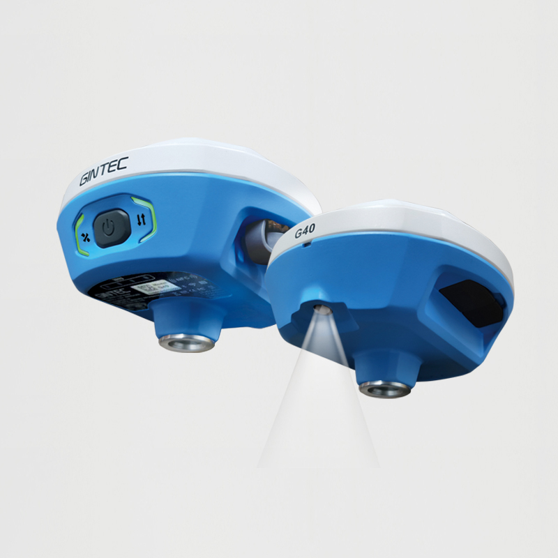

G40
GINTEC G40 AR GNSS receiver with revolutionary vision technology. Experience real-time visual layout, eliminating repetitive pole adjustments. Our professional-grade camera ensures clear visibility even in challenging lighting conditions. Our fusion algorithm combines satellite and inertial navigation with visual perception, replacing outdated compass-based systems. Enjoy unparalleled accuracy without magnetic interference.
With 1408 channels, the G40 enhances fixed performance by an outstanding 20% even in obstructed environments. Upgraded with our GINTEC 5 satellites + 21 frequencies solution engine, the chip’s computational power is boosted by 40%, enabling precise calculations using a wider range of satellite frequencies.


Key Features
Specifications
New-Generation SoC
Powerful GNSS SoC chip with 1408 channels
Supporting the new B1C, B2a, B2b, and BeiDou-3
G-FIX supported
Calibration-Free Tilt Compensation
Calibration and initialization FREE
Ready for tilt survey straight out of the box
G-FIX Correction Outage Technology
Extending RTK positioning up to 10mins
Reducing downtime waiting to re-establish RTK corrections
Built-in Battery. Quick Charge
Supporting USB 3.0/45W quick charge
Charging Time ≤ 3.5 Hours
Battery Life ≥ 2000 Circles
New Antenna Combination
Highly integrated GNSS,4G, WIFI, and Bluetooth antennas
Powerful Performance. Smaller Size
Anti-Interference Technology
Multi-frequency interference suppression and multi-step adaptive filtering technology
Receiving strong and stable signals in challenging conditions
Augmented Reality (AR)
Overlaying digital information onto the real world
Assisting to view the stakeout location and see designed features in real time
Professional Camera
High-resolution Night vision camera
Broad perspective, sophisticated algorithms guaranteeing the precision up to 1cm
Seamlessly combining 360-degree AR layout and image layout
G-FIX Correction Outage Technology
G-FIX Correction Outage Technology refers to the use of methods and techniques to mitigate the effects of GNSS correction data loss or outage,which is used to improve the accuracy of positioning by correcting errors caused by atmospheric and other environmental factors.
Widely used in
Surveying and Mapping / Geographic Information System / Agriculture / Aerospace / Oceanography and hydrology / Road and transportation / Construction
Brand-New Calibration and initialization FREE IMU
By utilizing a highly accurate Inertial Measurement Unit (IMU) and a unique tilt compensation function, RTK tilt measurement has been made practical.
No calibration required, GINTEC G40 RTK is ready for precise measurement from the moment when it is turned on, allowing instant use.
It is resistant to magnetic interference, making it suitable for use in any location.
RTK measurement is no longer bound by bubbles, realizing an efficiency improvement of at least 30%, and greater measurement accuracy is guaranteed.
AR Stakeout
Use an AR tool to visualize the location and position of a design feature or structure on a real-world site.This involves using a GNSS receiver to locate the position of the design feature or structure on the site, and then overlaying an augmented reality image of the feature onto the real-world view.This process helps the surveyors to accurately stake out the location of the feature or structure and ensures that it is built according to the design specifications.
| Positioning | |
| Channels | 1408 |
| GPS | L1CIA,L1C,L2P(Y),L2C,L5 |
| GLONASS | G1,G2,G3 |
| BDS | B11,B21,B31,B1C,B2a,B2b |
| GALILEO | E1,E5a,E5b,E6 |
| QZSS | L1,L2C,L5,L6 |
| NAVIC(IRNSS) | L5 |
| SBAS | L1C/A |
| PPP | B2B-PPP | E6-HAS |
| Data Update Frequency | 50HZ |
| Positioning Frequency | 1Hz 2Hz 5Hz 10Hz 20Hz 50Hz |
| Cold Start Time | <12s |
| lnitialization Time | <5s |
| lnitialization Confidence | >99.9% |
| Measurement Accuracy | |
| Static Mode Accuracy | H:+2.5mm+0.5ppm V:+5.0mm+0.5ppm |
| Single Point Solution Accuracy | H:1.5m V:2.5m |
| Differential Solution Accuracy | H:0.4m V:0.8m |
| RTK Accuracy | H:+8.0mm+1ppm V:+15.0mm+1ppm |
| Time Accuracy | 20ns |
| Tilt Measurement Accuracy | ≤2.5cm within 120° |
| Power | |
| Battery Life | Static 30h, Rover 20h, Base18h |
| Power Supply | Built-in Li-ion 9V/2A, 5V/2A, MAX18W 3.6V_6800mAh |
| Physical | |
| Material | Magnesium alloy main body. ABS/PC top cover |
| Dimensions | Φ130mm*70mm |
| Weight | 750g |
| Operation | |
| Button | Power Button |
| Indicator | Satellite Signal Light, Data Transmission Light, Current Battery Light |
| Camera | |
| 2 Mega CMOS image sensor | |
| Optical Format | 1/5 inch |
| Pixel Size | 1.75um*1.75um |
| Active Pixel Array | 1616*1232 |
| System | |
| Operating System | Linux |
| Memory | 8G |
| Data Transmission | 4G/BluetoothWIFI/Radio |
| Bluetooth | V5.0,BLE |
| WIFI | 802.11a/b/g/n |
| Radio Power | 1W |
| Radio Frequency | 410-470MHz |
| Radio Channel Quantity | Up to 99 channels |
| Air Baud Rate | 19200,9600,4800 |
| 4G Network |
LTE FDD: B1/B2/B3/B4/B5/B7/B8/B12/B13/B19/B20/B25/B26/B28 |
| Supported Protocols | Gintec Work,TrimTalk450s(T), TrimMark III, SOUTH, PCC-EOT, Hi-target, Satel, Farlink, etc. |
| Supported Languages | Chinese, English,Polish, Turkish, Korean, Indonesian, Spanish, Telugu, Russian, etc. |
| Data formats | RTCM2.x,RTCM3.x,CMR input/output, RINEX2.11,3.02,NMEA0183 output NTRIP Client, NTRIP Caster |
| Environment | |
| Operation Temperature | -30℃~+65℃ |
| Stock Temperature | -40℃~+80℃ |
| Waterproof Dustproof | IP68 |
| Shock and Vibration | Withstanding 2m pole drop onto the cement ground |
| Humidity | 99.9% |
SUPPORT
FOLLOW US


© 2023 Guangzhou Geosurv InformationTechnology Co., Ltd copyright ![]() 粤公网安备44011202003238号 粤ICP备20072763号-1
粤公网安备44011202003238号 粤ICP备20072763号-1
