


CONTACT US


Common Coordinates and Conversion Modes used in Geodetic Survey
In geodetic survey, the common used coordinate systems are Geodetic Coordinate System, Spatial Rectangular Coordinate System, Gauss-Krueger Plane Rectangular Coordinate System and so on. Based on the same reference ellipsoid, the above three coordinate systems are equivalent, corresponding with each other, only in different coordinate forms.

Geodetic Coordinate System
Geodetic coordinate system is the basic coordinate system for geodetic survey, the base for calculation in geodetic survey, study on the size for earth shape and map compilation.
Geodetic coordinate system takes the reference ellipsoid as the datum plane. The position of ground point P is represented by geodetic longitude L, latitude B and height H. Geodetic coordinates are used in geodesy, surveying and mapping, etc.
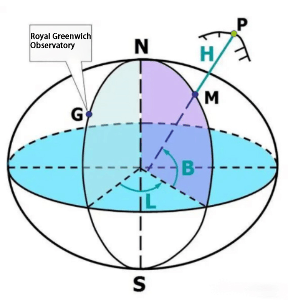
Principle of Geodetic Coordinate System: When a point is on the reference ellipsoid, it is enough to be shown only by geodetic longitude L and geodetic latitude B. Geodetic longitude L is the angle between prime geodetic meridian plane passing through Royal Greenwich Observatory and the geodetic meridian plane passing through point P. From prime geodetic meridian plane, eastward from 0° to 180° called east longitude; westward from 0° to 180° is called the west longitude. Geodetic latitude B is the angle between the equatorial plane and the normal through point P. From the equatorial plane, northward from 0° to 90° belongs to north latitude, southward from 0° to 90° is south latitude. Geodetic height is the distance from the ground point along with the normal to the reference ellipsoid.
Spatial Rectangular Coordinate System
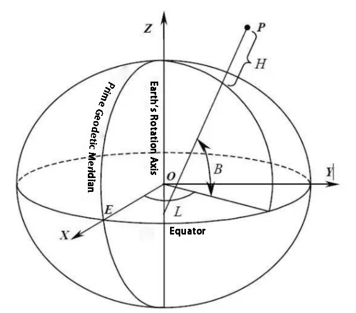
The origin of the spatial rectangular coordinate system is in the center of the reference ellipsoid. The Z-axis points to the north pole of the reference ellipsoid. The X-axis points to the intersection of the prime geodetic meridian plane and equator. The Y-axis is at the position with an angle at 90° from the X-axis on the equatorial plane at the right side. In spatial rectangular coordinate system, the coordinates of a point can be shown by the projection of the point on each axis of the coordinate system. The spatial rectangular coordinate system can be shown as follows:

Gauss-Krueger Plane Rectangular Coordinate System
It also can be simply called Gauss-Krueger Plane Coordinate System which is established by Gauss-Krueger projection. Gauss-Krueger Plane Coordinate System is a kind of plane coordinate system widely used in geodetic survey, urban survey, general survey, various engineering survey and cartography. Gauss-Krueger projection was proposed by German C.F. Gauss in 1822, and then expanded and improved by German J.H.L. Krueger in 1912. The geodetic coordinates shown in terms of geodetic latitude and longitude belong to the type of coordinates on the ellipsoid and can not be applied to mapping.
Therefore, the above coordinates shall be converted into plane rectangular coordinates. Generally, the conversion from Geodetic Coordinate(B,L) to plane rectangular coordinate(X,Y) can be shown in math as follows: X=F1(B,L), Y=F2(B,L), where F1 and F2 are projection functions.
The projection function of Gauss-Krueger projection is determined according to the following two conditions: First, the projection is conformal, namely that an infinitesimal figure on the ellipsoid is similar to its appearance on the plane, so it is also named conformal projection; the length ratio of any point on the projection plane(namely the ratio of the differential distance for a point on the ellipsoid to its corresponding differential distance on the plane) is independent of the orientation. Second, on the projection plane, the appearance of a meridian of the ellipsoid is a straight line with constant length, that is, the length ratio is equal to 1. This meridian is called the central meridian or axis meridian. These two conditions embody the characteristics of Gauss-Krueger projection.

Gauss-Krueger projection has the following characteristics:
1. After projection, the central meridian is a straight line with constant length. However, the other meridians are curves concave to the central meridian with changing length. and the meridians with the same meridian difference on both sides of the central meridian are symmetrical with each other.
2. The central meridian remains orthogonal to the equator after projection.
3. The latitude circle, which is symmetrical to the equator, still becomes a symmetrical curve after projection, and is perpendicular to the projection curve of the meridian, that is, the angle remains unchanged before and after projection. So Gauss-Krueger projection also is conformal projection.

Coordinate Conversion
Coordinate conversion is the position description of space entity, which is the process of transforming from one coordinate system to another. It is accomplished by establishing one-to-one correspondence between the two coordinate systems. Coordinate conversion is an essential step to establish the mathematical foundation of map in all kinds of scale map measurement and compilation.
In many engineering measurements, coordinates of the local coordinate system often shall be offered in the measurement result. In this case, the processing results of GPS measurement are required to be converted from WGS84 coordinate system to other local coordinate system. The methods of coordinate conversion are square grid, multiple parameter, multiple regression and so on.
Generally, there are Bursa Model, Molodensky Model, Weiss Model, Van's Model, etc. But the most commonly used one is Bursa Model. In terms of accuracy, the square grid is the most accurate. However, it is limited by the known conditions, it requires enough coincidence points distributed uniformly in the survey area. In many engineering measurements, like road, bridge, building, dam, tunnel measurement and so on, it is required to use local coordinate system, in which there are no enough coincidence points. Therefore, in the coordinate conversion of engineering measurements, square grid method is rarely used while parameter method is used more frequently.
At present, there are several common coordinate conversion in China:
1. Geodetic Coordinate(BLH) to Plane Rectangular Coordinate(XYZ)
Conventionally, before conversion, it shall confirm first the conversion parameter, namely ellipsoidal parameter, zoning standard(3°, 6°) and the longitude of the central meridian. The ellipsoidal parameter refers to what kind of the ellipsoid reference is adapted in plane rectangular coordinate system. The long axis, short axis and flat rate vary from different ellipsoid reference. When the coordinates are converted to rectangular coordinate system, they can be shown as (x+z*acosθ, y+z*asinθ)a, in which θ is the parameter.

2. Conversion between two Random Space Coordinate System
At least three coincidence points(namely the known points in both two coordinate systems) shall be required and then use Bursa Model to calculate when accurate conversion is needed but different standards are adapted in survey coordinate system and construction coordinate system.
________________________________________________________________________________________________
分享
SUPPORT
FOLLOW US


© 2023 Guangzhou Geosurv InformationTechnology Co., Ltd copyright ![]() 粤公网安备44011202003238号 粤ICP备20072763号-1
粤公网安备44011202003238号 粤ICP备20072763号-1
