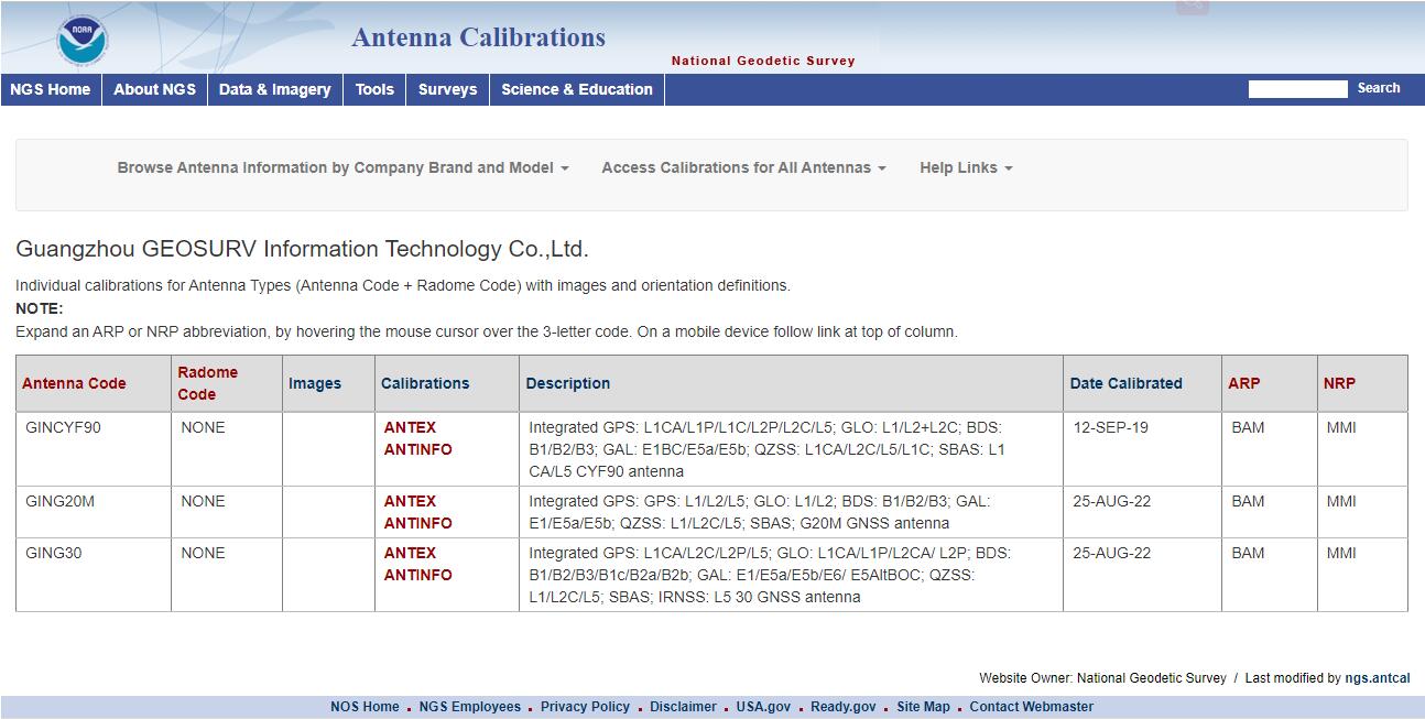
NGS Certification Finished on Antenna Calibration for G20M(New) and G30

发布于: 2022-09-06 18:23


Geodetic and precise GNSS measurements make the exact knowledge of the reception characteristics of the used GNSS antennas and therefore a calibration necessary. With the pursuit of high precision of products, GINTEC entrusted the third party, GeoService GmbH, to do antenna calibration on  G20M(New) and G30, corresponding to the certification name GING20M NONE and GING30 NONE. 


Robot-based Geo++R-GNPCV Real-Time Calibration is applied to get absolute GNPCV Type Mean. Absolute PCV acquired contain the following characteristics: absolute 3D offsets, absolute PCV, PCV from 0° to 90° elevation, elevation and azimuth dependent PCV, free of any multipath influence. The resulting PCV are completely independent from the used reference antenna and allow the complete modeling of the receiving characteristic of the antenna. This is required for a combined use of different GNSS antenna types or for differently orientated antennas. Therefore, antenna calibrated with this method are suited for All-In-View applications (e.g. use on reference stations). 


Antenna calibration results on G20M(New) and G30 have been updated in NGS website. It will be beneficial to improving customer experience on GINTEC products with high precision, which is always committed by GINTEC.


__________________________________________________________________________________________________________________________________

分享

推荐文章

  • 05-08 2026
    We are excited to announce the official global launch of Pocket2 Handheld SLAM, a cutting-edge 3D scanning solution designed to simplify complex workflows and deliver high-precision results across diverse industries. Already gaining traction in multiple countries, Pocket2 is now available for consultation and deployment, empowering professionals in interior measurement, forestry surveys, digital asset capture, robotics, and more. Key Features That Set Pocket2 Apart Multi-Modal Sensor Fusion for Unmatched AccuracyPocket2 integrates a global shutter camera, LiDAR, and IMU with the advanced MindSLAM® algorithm, enabling stable odometry and real-time, high-precision colored point clouds—even in dynamic or challenging environments. No training required: simply power on and scan. One-Tap Cloud Sync & Multi-Device CollaborationSeamlessly...
  • 03-06 2026
    The intercommunication between CY Software and GTS12A Android total station breaks the information barrier between equipment and software, realizing real-time transmission and two-way collaboration of measurement data. The GTS12A has strong on-site measurement capabilities, and the collected data such as horizontal angles and coordinates can be synchronized to the CY Software in multiple ways without manual intervention, avoiding data errors. The software can quickly complete data verification and processing, generate standard results, greatly improve the efficiency and accuracy of measurement operations, and provide a convenient solution for fields such as engineering surveying.  
  • 02-25 2026
    As GINTEC’s meticulously crafted core product, the G40PRO has stayed true to its quality commitment since launch. User-centric by design, it undergoes rigorous refinement in performance, configuration, and detail to pursue perfection, demonstrating outstanding product strength through differentiated core advantages. Powered by CAD technology and dual-camera collaboration, the G40PRO boosts overall setting-out efficiency by 40%, greatly reducing working hours. It delivers one-stop solutions for basic planning in transportation, energy, landscape, urban lighting, drainage, and security systems—seamlessly integrating design, surveying, and construction verification into a single workflow with efficient, uninterrupted processes, bringing users a convenient, efficient, and precise experience. GINTEC continuously empowers product upgrades through technolo...
  • toolbar