


CONTACT US

Global Navigation Satellite Systems (GNSS)
The term "global navigation satellite system" (GNSS) refers to a group of Earth-orbiting satellite constellations that broadcast their positions in both space and time, as well as networks of ground control stations and receivers that trilateration to determine ground positions. All modes of transportation, including mass transit, rail, road, aviation, and space stations, have employed GNSS. In telecommunications, land surveying, law enforcement, emergency response, precision agriculture, mining, finance, scientific research, and other fields, positioning, navigation, and timing (PNT) are essential. They are employed to manage power grids, air traffic, computer networks, and other systems.
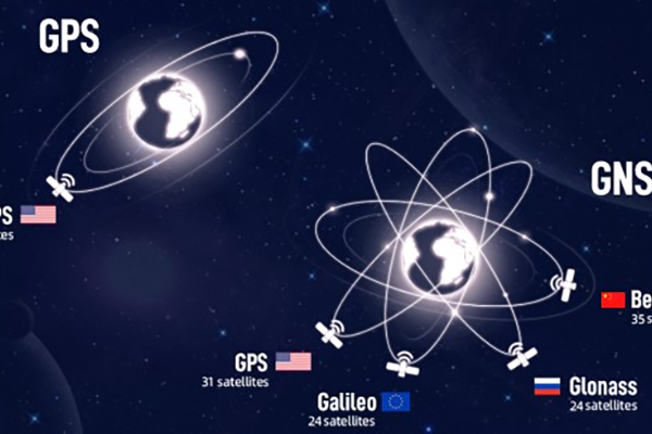
GNSS currently consists of four global and regional systems that are in development, including China's COMPASS/Bei-Dou, India's Regional Navigation Satellite System (IRNSS), and Japan's Quasi-Zenith Satellite System. Two of these systems are fully operational: the United States Global Positioning System (GPS) and the Russian Federation's Global Navigation Satellite System (GLONASS) (QZSS). The user will have access to location, navigation, and timing signals from more than 100 satellites once all these international and local systems are completely operational.
The Wide-area Augmentation System (WAAS) of the United States, the European Geostationary Navigation Overlay Service (EGNOS), the Russian System of Differential Correction and Monitoring (SDCM), the Indian GPS Aided Geo Augmented Navigation (GAGAN), and the Japanese Multi-functional Transport Satellite (MTSAT) are satellite-based augmentation systems that are available in addition to these. They can be used with tried-and-true terrestrial technology like inertial navigation to provide new applications with positive socioeconomic effects. These latter applications call for reliability or integrity in addition to accuracy. Applications in transportation that demand accuracy and integrity, like the landing of commercial airplanes, are safety-critical.
A GNSS user will be able to use one instrument to receive signals from many satellite systems once the International Committee on Worldwide Navigation Systems (ICGwork, )'s notably in creating interoperability among the global systems, has been completed. More information will be available as a result, and timing or position measurements will be more accurate, especially in urban and mountainous areas. To take advantage of these improvements, GNSS users must keep up with the most recent advancements in GNSS-related fields and develop their ability to use the multi-GNSS signal.
Therefore, the demonstration and comprehension of GNSS signals, codes, biases, practical applications, and the implications of potential modernization are the specific goals of the implementation of the GNSS priority area of the United Nations Program on Space Applications.
SUPPORT
FOLLOW US


© 2023 Guangzhou Geosurv InformationTechnology Co., Ltd copyright ![]() 粤公网安备44011202003238号 粤ICP备20072763号-1
粤公网安备44011202003238号 粤ICP备20072763号-1
